


History
The History of Baja
Recent History
The Mexican-American War (1846-1848) had major repercussions in Baja California. The war began after Mexico refused the United States’ offer to buy California, Nevada, Utah and parts of Colorado, Arizona, New Mexico and Wyoming. In the treaty ending the war, Mexico gave in to U.S. demands and ceded the vast territory in exchange for $15 million. The original draft of the treaty included Baja California in the sale, but the United States eventually agreed to omit the peninsula because of its proximity to Sonora, which is located just across the narrow Sea of Cortés.
In 1853, an American named William Walker invaded the peninsula with 50 mercenaries, intent on annexing the land for the United States. Although he had no support from the U.S. government, Walker sailed from San Francisco to La Paz, arrested the governor, took possession of the public buildings and raised the flag of a new republic. He even declared himself president and installed cabinet members. Without reinforcements, however, Walker was forced to retreat, first to Cabo San Lucas and eventually back across the border.
Being so distant from Mexico City, Baja California was relatively insulated from much of the political and social turmoil that plagued Mexico during the latter part of the 19th century. However, the territory did play a pivotal role in the Mexican Revolution. In 1911, a group called the Partido Liberal Mexicano (Liberal Mexican Party) organized a rebellion against the extended presidency of dictator Porfirio Díaz. Under Francisco Palomares and Pedro Ramirez Caule—both supporters of Francisco Madero, who initiated the Mexican Revolution in 1910—the rebel army took control of Mexicali in January 1911, followed by Tijuana in May. The success of the Partido Liberal Mexicano undermined the credibility of Díaz and the federal forces, encouraging rebel troops in other regions to join the fight.
As the revolution drew to a close in 1921, Baja California aligned itself with the new president, Venustiano Carranza. Throughout the remainder of the 20th century, the state’s cititens chose their leaders from the dominant political party, the PRI (Institutional Revolutionary Party), with the exception of Ernesto Ruffo, who was elected in 1989 as a representative of the PAN party.
On December 31, 1952, Baja California officially became Mexico’s 29th state, and in 1953 the state’s constitution was adopted. Previously, the region’s official name was Territorio Norte de Baja California, or Northern Territory of Baja California. Under the new constitution, Braulio Maldonado Sández of the Institutional Revolutionary Party (PRI) became the state’s first governor, presiding over a government whose unicameral legislative branch comprised 25 members.
Baja California Today
The state’s economy is bolstered by agriculture, maquiladoras (manufacturing assembly plants), mining and tourism. The state is also well known as a tourist destination, thanks to its countless beaches and proximity to the United States. With six border crossing points into the U.S. state of California, Baja California sees many thousand crossings each day. In 2000, an estimated 180,000 cars crossed the international border daily.
Tijuana is the largest Baja California city. Its population continually fluctuates as people arrive from the United States and Latin America countries while others depart for the United States.
Baja California`s sports fans enjoy proximity to several professional teams: the Mexicali Suns (basketball), the Mexicali Eagles (baseball), the Tijuana Colts (baseball) and the Tijuana Xoloitzcuintles (soccer).
Facts and Figures
- Capital: Mexicali
- Major Cities (population): Tijuana (1,410,700) Mexicali (855,962) Ensenada (413,481) Tecate (91,021) Playas de Rosarito (73,305)
- Size/Area: 56,017 square miles
- Population: 2,844,469 (2005 census)
- Year of Statehood: 1952
Fun Facts
- Baja California’s coat of arms features the state’s motto, “Work and social justice,“ emblazoned across an image of the sun that represents the state’s energy. Beneath the sun, a male figure holds a book, while a female figure carries a test tube; together, they grasp several lightning bolts, suggesting that the creative combination of culture and science can generate powerful energy. On the lower part of the design, a human figure with outstretched arms embraces the state’s three primary resources: agriculture, industry and the ocean. Two leaping fish on the sides denote the two bodies of water that surround Baja California—the Sea of Cortés and the Pacific Ocean.
- The peninsula of Baja California is 1,300 kilometers (800 miles) long, making it the world’s third-longest.
- The U.S. border crossing at Tijuana is one of the busiest in the world, with about 50,000 cars and 25,000 pedestrians coming and going each day.
- When the Spaniards arrived in the Baja California area in 1539, they believed they had reached a mythical island of female warriors governed by Queen Calafia. The earliest record of this myth appears in The Exploits of the Very Powerful Cavalier Esplandian, Son of the Excellent King Amadis of Gau, written by Garcia Ordonez de Montalvo 18 years earlier.
- The Guadalupe Valley, near Ensenada, supports several world-class wineries located in the old Nuestra Señora de Guadalupe del Norte mission. Visitors to the mission can enjoy wine tasting and vineyard tours.
- Olive Ridley (golfinas) and Leatherback (laud) turtles nest on the state’s beaches, returning each year to lay their eggs on the same beach where they were born.
- La Bufadora (the blowhole) is a natural marine geyser located a short distance from Ensenada. Ocean waves are forced into a partly submerged cave. The water and air in the cave mix and cause a pressure build-up. The pressure causes the water to explode upwards out of the cave, reaching heights of up to 24 meters (80 feet).
- El Altar, a site in San Pedro Mártir National Park, provides visitors with the unique opportunity to see both the Pacific Ocean and the Sea of Cortés at the same time.
Landmarks
Beaches
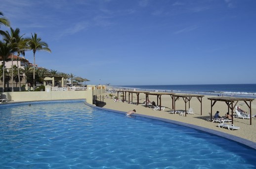
The beaches along Baja California’s two coasts vary tremendously. The western coast, which faces the Pacific Ocean, is characterized by cool water, ocean swells and occasional heavy surf. The eastern coast faces the narrow Sea of Cortés and generally has calmer waters.
Each year, thousands of tourists travel to Baja to take advantage of sport fishing at Ensenada, San Felipe, Mexicali, Bahía de Los Ángeles and San Quintín.
Wine Country
The northern part of Baja California has an ideal climate for grape growing; the valleys of Calafia, Guadalupe and San Antonio de las Minas constitute the heart of the Baja California wine country, producing a wide variety of wines such as chardonnay, chenin blanc, sauvignon blanc, barbera, cabernet, syrah, tempranillo, merlot and cabernet franc. The Bodegas de Santo Tomas wineries continue to use the grape varieties planted by Jesuit missionaries in the 18th century.
Spanish Missions
Although the area resisted European colonization for more than a century after its discovery, the Spanish eventually colonized it by establishing missions. Many of the missions are in poor condition or have disappeared completely, but tourists still visit sites such as Misión San Vicente Ferrer, Misión El Descanso and Misión San Miguel Arcángel de la Frontera.